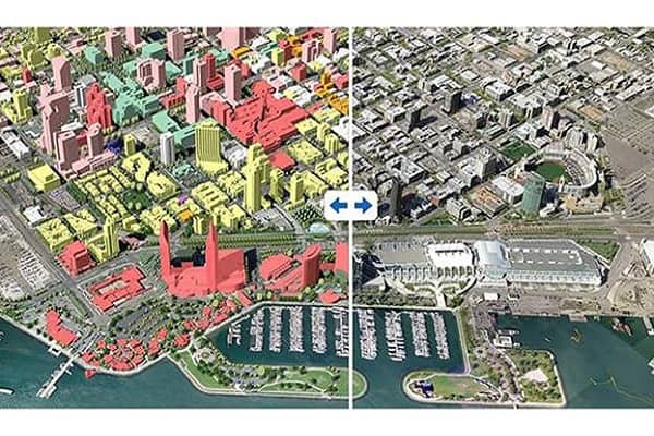
Many free software applications can help urban designers do their work. Sketch Up, for example, is a powerful 3-D modeler that can be used to create visualizations of cities, neighborhoods, and buildings. While it does have its limitations, it is also free and can be integrated with Google Earth. Likewise, Inkscape is a vector-based open graphic manipulation application comparable to Adobe Illustrator.
Contents
Vector-Based Graphics Tool
Another free option is GIMP or Inkscape. This vector-based graphics tool is an invaluable tool for urban planners. This app can create maps and edit lines easily, which is comparable to Adobe Illustrator. This app is easy to use and is an excellent alternative to the expensive Best software for urban planning such as Revit. But there are some limitations to these programs. You might want to try the free version to see how useful it can be.
Create 3D Cityscape Designs
For example, Google Earth is one of the best free urban design software programs. This program can be used for a variety of applications. For instance, it can create 3D cityscape designs from any data available. It’s also compatible with other popular architect design software. You can download it here. It’s worth looking if you want to create an urban design project. It’s a great way to visualize and plan a city.
Urban Design Projects
ArcGIS is another excellent option for urban design projects. This free software helps create immersive and interactive cities. It also allows project managers to manage different departments and evaluate performance. The best part is that you don’t have to pay for a subscription to use these tools. And there are many more options. Once you’ve downloaded a trial version, you’ll be able to try out the full version in no time.
Open-Source GIS
QGIS is an open-source GIS that is compatible with ArcGIS and Esri ArcGIS. It’s the best choice for planners who want to expand their design capabilities. The software also allows you to see multiple layers of mapped data and combine elements and locations. It can measure distances and create figure-ground maps in a snap. And, it’s free!
Urban Planners & Architects
Google Earth is an essential tool for urban planners and architects. The axonometric view is constructive for urban designers and planners. It allows them to view the area from a low-flying plane. Other settings in Google Earth will enable you to view the entire world differently and measure distances. The software is also compatible with SketchUp and GIMP. You can explore the world with this software.
Also read: What is the Most Used Construction Estimating Software?
Online Street Design Software
Streetmix is an open-source online street design software that allows you to create proposals with 3D models. It will enable you to compare different development proposals side by side and analyze design solutions. The software can also be downloaded for offline use. Furthermore, it allows you to communicate with colleagues in real-time. With this software, you can share your ideas with others quickly and efficiently. You can also collaborate with others through the web.
If you’re a beginner, you can use the free software. It has everything you need to create floor plans and other architectural elements. You can use it to collaborate with the rest of the team. It also includes features that interior designers and construction firms can use. The best software allows you to share your ideas and create realistic renderings. It’s free, so it’s worth a try.
Final Words:
The software should be free of any limitations. There are also several paid versions. Most of them have advanced features. Some of them are also produced. If you’re a self-employed designer, you can use the software for free. But if you’re working alone, you should avoid spending any money. These are the alternatives. You should always choose the one that works best for your work. If you’re not a professional, you can download the paid version.


